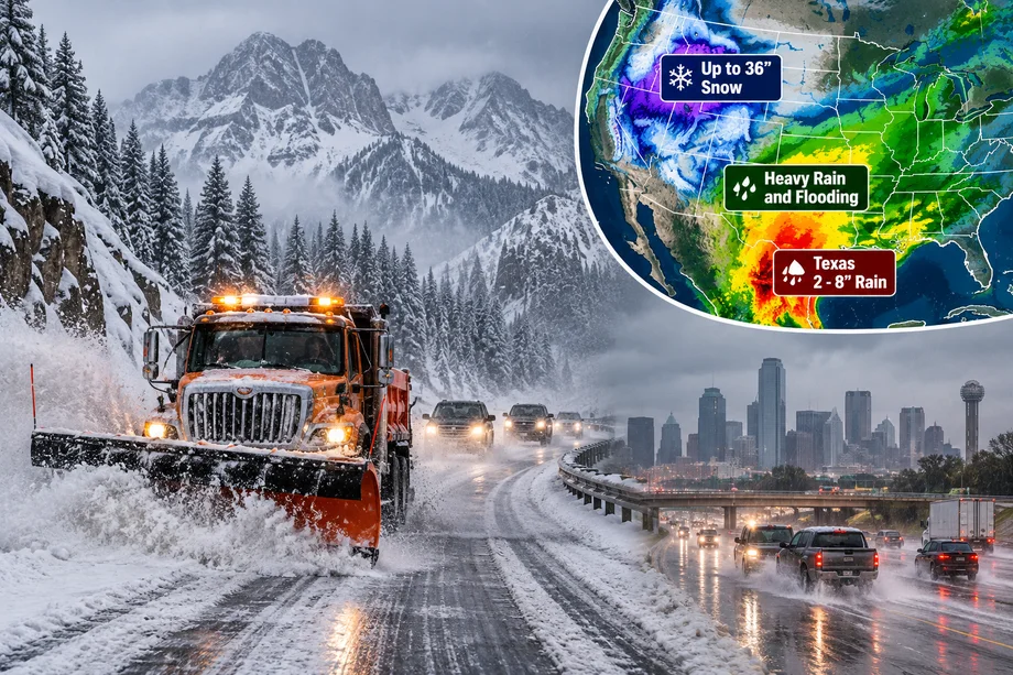
An unusually complex storm system is spreading dangerous weather across large parts of the United States, bringing the possibility of heavy early season snow to the mountains while millions of people farther south and east face flooding and severe thunderstorms.
The developing system is combining deep tropical moisture left behind by former Hurricane Polo with a slow moving weather pattern moving across the western and central United States.
The result is a striking contrast for the final day of September.
Some mountain locations could receive significant snowfall, while parts of Texas, Oklahoma and the central Plains face several inches of rain and a growing flash flood threat.
National Weather Service forecasts and local weather alerts show conditions could remain hazardous through Thursday and into Friday in some areas.
Up to 36 inches of snow possible in the mountains
The most dramatic snowfall projections are concentrated at high elevations rather than major population centers.
Some National Weather Service probability forecasts show high end snowfall amounts approaching 36 inches in isolated mountain locations by Friday evening.
Those figures represent upper range possibilities rather than a prediction that three feet of snow will fall widely.
More broadly, several mountainous areas could receive substantial accumulations as colder air interacts with moisture moving through the West.
Strong winds could make conditions considerably worse.
Gusts approaching 50 mph are possible in some exposed areas, creating reduced visibility and difficult travel where snow becomes heavy.
An unusual start to October
Heavy mountain snow itself is not unprecedented at this time of year.
Higher elevations across the Rocky Mountains can experience snow during September and October.
What makes the current system notable is the combination of early season cold air with large amounts of tropical moisture.
That moisture can dramatically increase precipitation when it is forced upward over mountainous terrain.
At lower elevations, the precipitation falls primarily as rain.
Higher in the mountains, colder temperatures allow that moisture to become snow.
The same broad weather system can therefore produce winter conditions in one location and dangerous flooding hundreds of miles away.
Hurricane Polo moisture fuels the storm
Former Hurricane Polo is an important part of the developing weather pattern.
Polo previously moved across northwestern Mexico before its remnants pushed moisture into the southwestern United States.
That tropical moisture has already contributed to significant flooding.
The Washington Post reported nearly 100 flood related storm reports across the region since Monday, with Arizona, Nevada and southern New Mexico among the areas affected.
Vehicles were swept away in some locations, while evacuation orders were issued in vulnerable communities.
As Polo's remnants move farther east, the moisture is interacting with another weather system.
That interaction is expanding the threat into the Plains and Texas.
Texas faces a major flood threat
While snow attracts attention farther north and at higher elevations, flooding may present the more immediate danger to populated areas.
Large sections of Texas are preparing for potentially intense rainfall.
Flood watches have been issued for several areas as thunderstorms develop along and ahead of a slow moving cold front.
Parts of North and Central Texas could receive 2 to 5 inches of rain, with isolated totals potentially reaching 8 inches.
Dallas, Fort Worth, Waco, Killeen and surrounding communities are among the areas being monitored closely.
The greatest danger comes from thunderstorms repeatedly moving across the same locations.
Dallas faces dangerous rainfall rates
The Dallas Fort Worth region could experience particularly heavy rainfall.
The Weather Prediction Center has highlighted parts of Texas and Oklahoma for an elevated risk of excessive rainfall.
Rainfall rates could become intense enough to overwhelm roads and drainage systems.
The threat is complicated by recent dry conditions.
Dallas recently ended an extended dry period, leaving some areas with hard ground that may struggle to absorb sudden heavy rainfall efficiently.
Instead of soaking into the soil, intense rain can rapidly run into streets, creeks and low lying areas.
San Antonio could receive up to 8 inches
South Central Texas is also preparing for heavy rain.
Forecasts for the San Antonio region call for widespread totals of approximately 2 to 4 inches, with isolated locations potentially receiving as much as 8 inches.
The heaviest rain is expected as the front moves through the region.
Thunderstorms could produce rainfall rates exceeding 2 inches per hour in isolated locations.
That would be sufficient to create flash flooding quickly, particularly on roads and in urban areas.
Damaging wind gusts and small hail are also possible with stronger thunderstorms.
Houston could face two rounds of rain
Houston's forecast is more uncertain, but the flood threat could eventually shift farther east.
Meteorologists are monitoring the possibility of two separate rounds of heavy rain affecting Southeast Texas.
The first is connected with the slow moving front and moisture from former Hurricane Polo.
Another surge of Gulf moisture could then affect coastal areas later.
Current forecasts suggest Southeast Texas could generally receive 1 to 3 inches during the initial system, although higher totals are possible depending on where the front stalls.
The precise position of that boundary will determine which communities experience the heaviest rainfall.
Central US also faces flooding
The storm will not stop in Texas.
Moisture is expected to spread through parts of Oklahoma, Kansas, Nebraska, Iowa, Missouri and Illinois.
Some locations around Omaha and Des Moines could receive several inches of rain.
Flash flooding becomes more likely when thunderstorms repeatedly follow similar paths.
Meteorologists call this process training.
Individual thunderstorms may not last particularly long, but a sequence of storms moving over the same area can produce dangerous rainfall totals.
Severe thunderstorms could develop
Flooding is not the only concern.
Some thunderstorms could become severe as the system crosses the central United States.
Damaging winds, hail and isolated tornadoes are possible in parts of the affected region.
The precise severe weather threat will depend on atmospheric instability and the timing of the cold front.
Residents should therefore monitor local warnings even if their community is not currently expecting extreme rainfall.
Weather conditions can change rapidly when powerful systems interact with tropical moisture.
Why is snow falling so early?
September snow can seem surprising, particularly when much of the United States is still experiencing relatively warm weather.
Elevation makes an enormous difference.
Temperatures decrease as altitude increases.
Mountain peaks can therefore experience freezing conditions while valleys below remain much warmer.
When a moisture rich storm arrives at the same time as colder air, heavy mountain snowfall can develop rapidly.
The Rockies regularly experience dramatic weather changes during autumn.
A warm afternoon at lower elevations does not necessarily mean nearby mountain passes will remain snow free.
Drivers could face difficult mountain travel
The snow forecast has significant implications for anyone traveling through higher elevations.
Heavy snow can quickly cover roads.
Strong winds can reduce visibility.
Temperatures near freezing can create icy surfaces.
Transportation agencies can introduce traction requirements or temporary road restrictions when conditions deteriorate.
Drivers heading into mountainous areas should check local forecasts and road conditions before traveling.
Vehicles prepared for warm September weather may not necessarily be equipped for sudden winter conditions.
Snow totals require context
Forecast maps showing extremely high snowfall amounts can easily be misunderstood.
A map displaying up to 36 inches does not mean every community inside a large region will receive three feet of snow.
Those values can represent high end probabilities in isolated mountainous terrain.
Actual snowfall depends heavily on elevation, storm track, temperature and local geography.
Many lower elevation communities could receive rain instead of snow.
Even within mountainous areas, totals can vary dramatically across relatively short distances.
Flooding remains the greater widespread threat
Despite the attention surrounding snow, flooding is likely to affect a much larger population.
The remnants of Polo have already produced significant rainfall in the Southwest.
Now the threat is moving east.
Texas is particularly important because major metropolitan areas could experience heavy rainfall.
Dallas Fort Worth alone has millions of residents, while San Antonio, Austin and Houston could also see periods of intense rain as the system evolves.
Flash flooding is especially dangerous because conditions can deteriorate within minutes.
Never drive through flooded roads
Authorities repeatedly warn drivers not to enter flooded roadways.
Water depth can be difficult to judge, particularly at night.
A road may also have been damaged beneath the water.
Even relatively shallow moving water can push vehicles away from the roadway.
Drivers who encounter flooding should turn around and use another route.
Many flood deaths in the United States occur inside vehicles.
What happens next?
The storm system will continue evolving as the tropical moisture moves east and interacts with the cold front.
Heavy rain and flooding remain possible across parts of the central United States through Thursday and Friday.
Mountain snow could continue where temperatures remain sufficiently cold.
Some areas could also experience strong winds and severe thunderstorms.
The exact location of the heaviest precipitation will change as the system moves.
For millions of Americans, the beginning of October could therefore feel dramatically different depending on location.
Some communities are preparing for flooded roads and thunderstorms.
Others could wake up to mountains covered in snow.
And in the highest elevations, an early taste of winter could deliver snowfall measured not in inches, but potentially in feet.